> next page (monitoring)
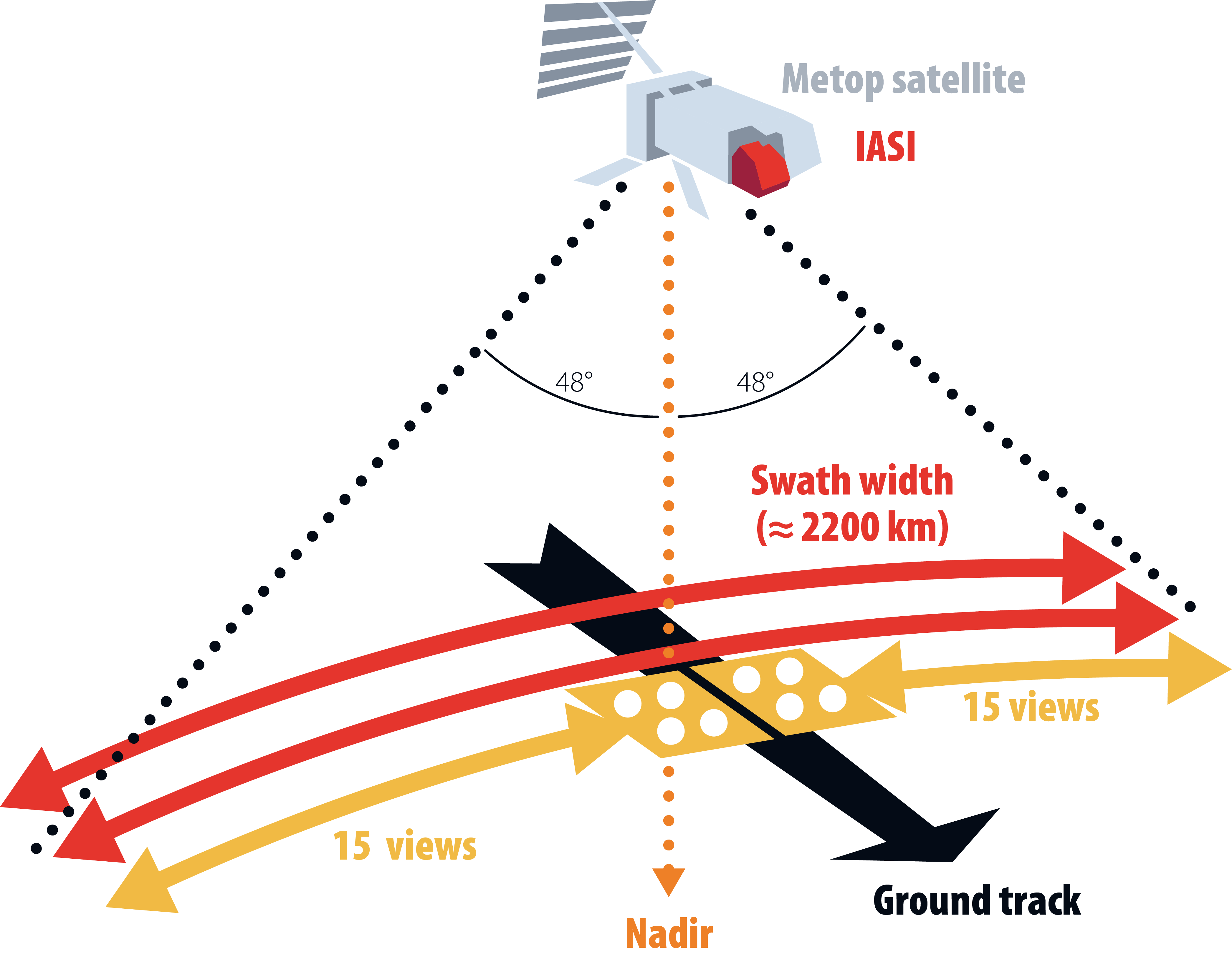
The IASI instrumentThe IASI instrument was designed by the Centre National d’Etudes Spatiales (CNES) to monitor the atmospheric state for weather prediction and climate/chemistry purposes. More specifically to measure accurate temperature and water vapour profiles, as well as the concentrations of infrared-absorbing atmospheric constituents, twice a day at almost each location. It is flying onboard the polar-orbiting Metop-A -B and -C satellites, which were launched in October 2006, September 2012 and November 2018, respectively. This meteorological platform is the space segment of the Eumetsat Polar System (EPS) programme, which consists of a series of three Metop satellites, to be launched sequentially in order to provide observations for more than 14 years, together with the relevant ground facilities. Measurements are performed from the Metop polar orbit, at an altitude of around 817 km. The satellite is sun-synchronous with a 98.7o inclination to the equator, and the satellite’s ground track is at about 09:30 local time in the morning and 21:30 in the evening. The time to complete an orbit is about 101 min, which implies that Metop makes a little more than 14 orbits per day. IASI is based on an advanced Fourier transform spectrometer associated with an imaging system that uses nadir geometry to record the changes in the Earth’s emitted radiation due to absorbing gases along the optical path. The instrument uses several detectors to fully cover the spectral range that extends from 645 to 2760 cm-1 (15.5 to 3.62 µm) with 0.5 cm-1 spectral resolution (apodized). The raw spectra are of high radiometric quality, with a noise equivalent temperature difference lower than 0.2 K for wavenumbers lower than 2200 cm-1, except for the narrow portion between 1800 and 2000 cm-1 where it approaches 0.3 K. To achieve global coverage, the IASI instrument observes the Earth up to an angle of 48.3o on both sides of the satellite track. This corresponds to 2×15 mirror positions and a swath of about 2×1100 km. Each instantaneous field-of view (3.3o×3.3o or 50 km×50 km at nadir) is composed of 2×2 circular pixels, each corresponding to a 12 km diameter footprint on the ground at nadir (see Figure 1). More information about the IASI instrument and the Metop satellite can be found on the dedicated sites of CNES and Eumetsat, while Table 1 presents a summary of their basic characteristics. Additionally, information about the geophysical measurements using IASI can be found in the next page, with emphasis on the trace gases retrieved at LATMOS.
Figure 1. IASI observing mode: the instrument measures the spectrum of infrared radiation emitted by the Earth
Table 1. Characteristics of the Metop satellite and of the IASI instrument. |


Site Guyancourt Tél : 01 80 28 50 21 |
Site Paris-Jussieu Tél: 01 44 27 90 77 |
|
|
|||||
|
© LATMOS, 2018 |
Kit Presse | |||||||